As the Arctic wakes up from its polar night, Dr Adam Booth is leading a team of UK geophysicists on a two-week campaign of seismic investigations on Storglaciären, a mountain glacier in northern Sweden. He will be reporting on the expedition in a series of posts published here in GeoLog. This is his third post. If you haven’t already done so, be sure to check out his first and second posts.
This update comes half way through our stay in Tarfala and, coincidentally, half way through our scheduled work programme! If the weather stopped us working for the first few days of our stay up here, we’ve well-and-truly made up for lost time since then. The cold weather arrived (and still lingers: -12°C in Tarfala Valley today!), so the station’s snowmobiles had no problem making the 300m climb up the hardened snow at Storglaciären’s front to deliver the heaviest of our equipment to the survey site. The result is that we’re on schedule, and getting some very promising data (I’ve also found time to celebrate my 31st birthday, and enjoy a specially-made raspberry cake…!).
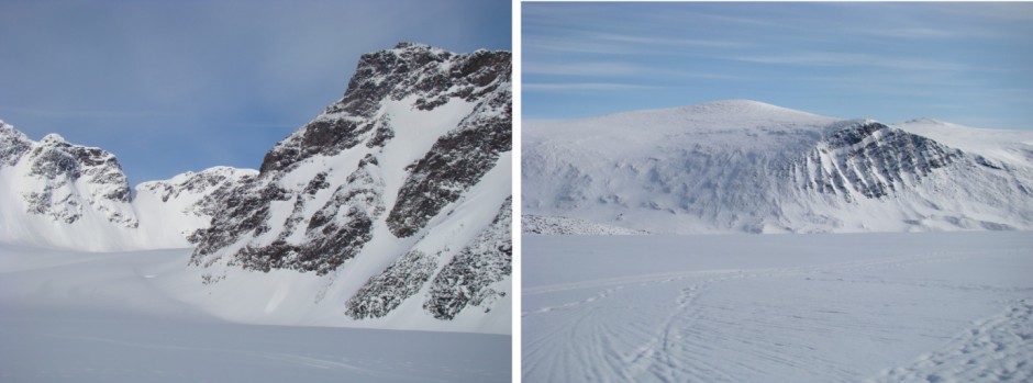
My first view from Storglaciären came on Wednesday (28 March), while overseeing the transport of our kit. After Tuesday’s difficulties, there was a real sense of satisfaction in finally getting up there. Nonetheless, when you hear the snowmobile’s engine struggling against a sled of cargo and the frontal slope of Storglaciären, it’s easy to think that this isn’t your lucky day either! But then the engine noise calms a little as the surface levels out, and you realise that the hardest part is over and the glacier has decided to cooperate after all! So, I’m pleased to present the first views this spring across Storglaciären and Tarfala Valley.
Photos from Storglaciären: Left: a west-looking view into the accumulation area of the glacier. Right: looking east back into Tarfala valley, at the mountains on its opposite side, just beyond the steepest part of the climb.
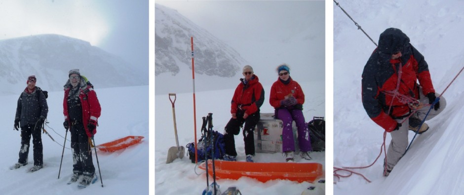
Each morning, Roger, Charlotte, Tavi and I set off from Tarfala and head up to the glacier. The 2km journey takes a little over an hour, but this depends on how much equipment we’re carrying. Although snowmobiles handle our heaviest items, the batteries for the seismic system require recharging so are ferried back and forth each day. I therefore tow a sledge of gear behind me… it’s a difficult trudge, but a great way to keep warm – plus, I feel some small connection with the earliest polar explorers! Walking around the glacier is generally pretty safe: there are crevasses in places but, at this time of year where we’re working, they are snow-covered so the chances of an accident are slim. Nevertheless, we carry rope and harnesses just in case – and undertook last-minute rescue practice on a frozen snowdrift at the station!
Out and about on the ice. Left: Roger and me, ready for the walk back to Tarfala at the end of a day. Centre: Tavi and Charlotte lunching on the glacier. Right: Roger refreshes his crevasse rescue skills, before heading up to Storglaciären.
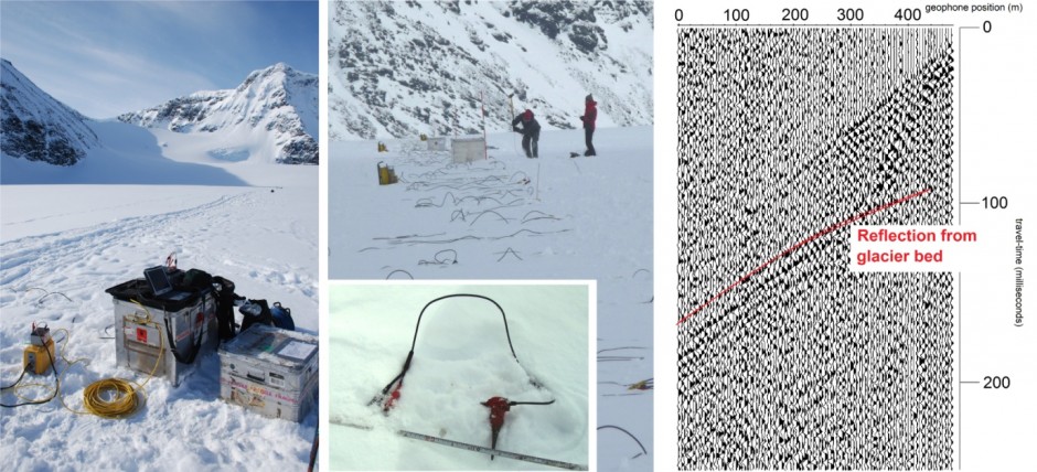
So, what does a seismic survey involve? Basically, we deploy a line of sensors (geophones) and connect them through several hundred meters of cable to a control laptop. The geophones are buried around 50cm in the snow, to reduce the noise caused by the wind. We then generate seismic energy at some known location, and record the output from the geophones – and, a bit like using an echo-sounder, we expect to identify seismic reflections from Storglaciären’s bed. In our survey, we have two seismic sources at our disposal. The first simply involves whacking the surface of the glacier with a sledge hammer! As inelegant as this method sounds, the data we’ve recorded actually look better than those produced with the second source – namely a ‘buffalo gun’. This involves loading a small explosive charge (actually a blank shotgun cartridge) into a steel pole, and firing it at a depth of around 1m in the snow. The photos below show various elements of the seismic survey, and some hot-off-the-press data. Our specific equipment is a Geometrics GEODE system.
Underway with seismic surveying. Left: Roger’s seismic ‘office’ on the glacier, from where the survey is managed. Centre: A seismic shot with the sledge hammer; all the cables in the foreground connect up the geophones (inset, before being buried!). Right: A first-look at some seismic data. The red curve highlights what we’re here for – reflections from the glacier bed!
The best interpretations from our seismic data also need reliable information about Storglaciären’s surface topography and the thickness of its snow cover. For these, we’ve brought along two other bits of kit: a differential GPS for obtaining a topographic profile, and a ground-penetrating radar (GPR) for measuring snow thickness. Leaving Roger to finalise the seismic setup, Tavi surveyed the line with a GPS, while Charlotte and I made a snow profile with the GPR. Radar is really effective for this job: it’s very fast, and provides high-resolution subsurface images. In fact, the resolution is so high that in addition to imaging the base of the snow, we also get responses from our buried geophones, so these data are also great for accurately measuring their depth!
GPR system and data. Left: Our GPR (a Sensors and Software PulseEKKO PRO), deployed on the Storglaciären. Right: The image that the GPR produces! The main stripe is the snow-ice interface (at around 1.5m depth), and the responses above this come from our buried geophones. The disturbed region at the ice-snow interface is probably a snow-filled crevasse, and we can make out responses to deeper englacial features (e.g., channels, entrained rocks etc).
So, it’s all systems go! We’re using Sunday to check the data we’ve recorded, and tomorrow we’ll again be heading up to Storglaciären to continue shooting. I’ll update you mid-week – for now, thanks for checking up on us!
Links:
Geometrics
Sensors and Software
One of a number of polar explorers, in his centenary yearBy Adam Booth, post-doc at Swansea University


