This week’s Imaggeo on Mondays is brought to you by Olivier Galland, who took this photo during an incredible outreach adventure in the Andes…
“Constructions” by Olivier Galland, distributed by the EGU under a Creative Commons licence. This photograph is also part of a larger exhibition, which was exposed at the EGU General Assembly 2013 in Vienna.
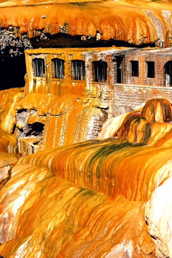
The image displays the spectacular Puente del Inca (The Inca Bridge) hot springs, in the Argentinian Andes of the Mendoza province, along the Vacas River, close to the foot of Cerro Aconcagua. When the mineral-rich, sulphurous waters reach the surface, they release CO2 in the form of calcium carbonate. This particular form of calcium carbonate is known as travertine. Over geological times, the travertine structures have grown to form a natural bridge over the river.
The colourful patterns are due to the development of bacteria and algae, enhanced by the environment enriched in minerals. The buildings, now entrapped in the petrifying springs, are remnants of a large thermal resort and spa built in the early 20th century.
The photograph was shot during an outreach project known as the Andean Geotrail. The project was based on a 9-month cycling adventure of two geologists (Drs. Caroline Sassier and I) along the Andes Mountains from Ushuaia, Southern Argentina, to Nazca, Peru, to promote Earth Sciences to the young public. During the adventure, we visited spectacular geological localities illustrating various aspects of Earth Sciences and their implications: Natural resources, Natural hazards, and Geoscapes. The Puente del Inca was naturally one of these localities. We shared our observations and experiences with 600 pupils in France and Norway with a blog too.
By Olivier Galland, University of Oslo
Imaggeo is the EGU’s open access geosciences image repository. A new and improved Imaggeo site will be launching soon, so you will be able to peruse an even better database of visually stunning geoscience images. Photos uploaded to Imaggeo can be used by scientists, the press and the public provided the original author is credited. Photographers also retain full rights of use, as Imaggeo images are licensed and distributed by the EGU under a Creative Commons licence. You can submit your photos here.