This week in GeoTalk, we’re talking to Steven Smith, a Lecturer from the University of Otago. Steven takes us on an Earth-shaking journey, explaining how ancient faults reveal what’s happening under the Earth’s surface and delving into the future of fault zone research.
First, could you introduce yourself and tell us a little about what you are currently working on?
Last September I started as a Lecturer at the University of Otago in New Zealand. My work focuses on understanding the structure and evolution of tectonic fault zones in the continental crust. I graduated from Durham University (England) back in 2005 and remained there to complete my PhD, studying a large fault zone exposed on Italy’s Island of Elba. My Italian connection continued as I then moved to Rome for 4 years to undertake a post-doc with Giulio Di Toro and Stefan Nielsen at the INGV (National Institute of Geophysics and Volcanology). In Rome I was working on a large group project funded by the European Union. The project involved integrating field and experimental work to better understand some of the extreme deformation processes that occur in fault zones during earthquakes. When my post-doc finished, I relocated to New Zealand, attracted by the research opportunities available here and the wonderful places waiting to be explored!
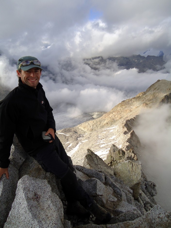
Steve on the summit of Lobbia Alta (3,195 m), a peak in the Adamello area of the Italian Alps. This area is part of a large Tertiary magmatic batholith that is cut by several fault zones Steve studied as part of his post-doc work. (Credit: Steven Smith)
Last year, you received a Division Outstanding Young Scientists Award for your work on the structure of shear zones. Could you tell us a bit more about your research in this area?
I work mainly on so-called “exhumed” fault zones – those that were once active and have been brought to the surface of the Earth by millions of years of uplift and erosion. By studying the structure of exhumed fault zones we can understand a lot about the physical and chemical processes that are active when faults slip. I have worked on fault zones in Europe that were exhumed from both the middle and upper crust. I’m particularly interested in the crushed-up rocks in the cores of fault zones (better known as fault rocks) and what these can tell us about fault zone rheology and deformation processes.
In the last few years, we have identified a number of previously-unrecognised textures in the cores of large normal and thrust faults in Italy. These include faults with highly reflective “mirror-like” surfaces and small rounded grains resembling pellets. Our work focused on trying to understand the significance of these textures, and in doing so we had to develop new experimental methods to deform fault zone materials under more realistic conditions. By comparing our field observations to the experimental data, we realised that the textures we identified probably represent ancient “fossil” earthquakes preserved in the rock record.
When thinking of a fault zone, you don’t often think small. How can you scale down what’s going on to create a laboratory-sized experiment?
That’s a very good question, and something that experimentalists have to be aware of all the time. It’s generally not possible to reproduce in the laboratory all of the conditions that a natural fault enjoys, which is why laboratory work ideally has to be integrated with other data, such as field observations of natural faults and theoretical modelling. But it is possible to perform experiments at quite realistic pressures and temperatures, and some deformation apparatus can deform fault zone samples over a very wide range of slip velocities – the sort you would expect during the seismic cycle along natural faults.
Laboratory experiments allow us to produce data on rock strength and fault zone behaviour that simply wouldn’t be possible by any other means. At the same time, it’s important to bear in mind that a small laboratory experiment might represent the behaviour of only a single point on a much larger fault surface – that’s where complementary field and geophysical observations come in. Looking at fault geometry and fault zone evolution over time helps put lab studies into context.
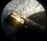
Admiring the inner workings of a fantastic fault on the Italian Island of Elba. (Credit: Bob Holdsworth, Durham University)
How does deformation differ across the world’s fault zones?
In the last few years, seismologists have detected different types of slip behaviour along active faults, from those that creep along steadily at rates of a few millimetres per year to those that fail catastrophically in earthquakes. In between there are other types of slip behaviour seen in seismological signals (such as seismic waves) from the deeper parts of fault zones like the San Andreas fault and the Alpine fault in New Zealand. Understanding the basic controls of this rich variety in fault slip behaviour is one of the key goals of modern earthquake science. Geologists studying exhumed fault zones have also long recognised that fault zone structure in the crust is very complex and highly dependent on factors like the type of host rock, level of exhumation, availability of fluids and so on. A future goal for geologists like me is trying to understand whether different types of fault slip behaviour recognised in modern-day seismic signals are preserved in the structure of fault zones in some way.
Is digital mapping an essential tool for the modern-day structural geologist? How does it help?
As in most branches of science, digital technologies are now increasingly used for geological mapping purposes, although a majority of universities still favour the traditional pen-and-paper approach to training students in geological mapping. In many mapping situations – ranging from reconnaissance-scale mapping to detailed surface topography measurements – there are a number of benefits to a digital approach, the main one being that field data are automatically located using GPS or laser-based technology. This opens up a range of possibilities to map and study 3D structures that would be difficult and time-consuming, if not impossible, using more traditional approaches.
I certainly think that digital technologies will play an increasingly important role in geological mapping and research in the future, and the technology will inevitably become more fit-for-purpose and affordable. I recently taught a short workshop on digital mapping to a group of 4th year students in Otago; after a few days they were all quite confident using handheld computers and GPS devices to map, and I think they were impressed by the ease with which the digital data could be analysed to better understand the inherent complexities of geological structure.
Finally, will you be working on faults in the future or moving on to pastures new?
I think there are a lot of important research problems to tackle in fault zones, so it’s likely I’ll continue working on faults in a broad sense in the future. The devastating Tohoku-oki earthquake and tsunami in Japan in 2011 highlighted that our understanding of fault zones is far from complete. My post-doc experience has convinced me that integrating field and experimental work is a promising way to understand fault zone processes. At the moment I’m particularly interested in the very-small scale frictional processes that occur on fault surfaces during earthquakes, and I’m currently using some of the analytical equipment here in Otago to study experimental samples that were deformed under earthquake-like conditions.
If you’d like to suggest a scientist for an interview, please contact Sara Mynott.