When a volcano erupts and spews lava onto the surrounding terrain, it is merciless in its destruction. All that is green on the land is engulfed in flame, or buried by an insurmountable mass of molten rock. Whatever charred remains of what lies beneath it will not see the light of day once the lava cools, turning the landscape into a barren black mass of solid basalt.
But volcanoes around the world are not barren basaltic masses. On the contrary, many volcanic slopes are teeming with life. Much of the Hawaiian archipelago is a tropical paradise, its older lava fields thick with forest and foliage. Likewise, Iceland’s flotilla of fiery peaks hasn’t rendered the land completely barren. So how does life return to the scene after an eruption?
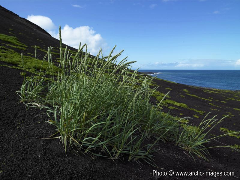
Hardy grass on Surtsey’s black sands. (Credit: Ragnar Sigurdsson (arctic-images.com via imaggeo.egu.eu)
The answer lies in a process known as succession. One by one, starting with the hardiest life forms, the lava is recolonised by wind-blown spores and seeds that have managed to make it from areas unharmed by the latest eruption. Over time, the growing community of plants attracts animals that bring further seeds to the site, either clinging desperately to their fur, or deployed stealthily in their droppings.
A long-term investigation of two very different volcanoes has revealed what allows the earliest arrivals to take hold: Surtsey, an isolated volcanic island in the North Atlantic, and Mount St. Helens, a once towering and peak in Washington State. The findings are published in Biogeosciences, an open access journal of the European Geosciences Union.

Surtsey’s arrival in 1963 (left, credit: NOAA) and Mount St Helens during the 1980 eruption (right, credit: Austin Post/USGS)
Surtsey emerged off the Icelandic coast in 1963 amid billowing plumes of ash and steam. Erupting from underwater, Surtsey created its own island – a fresh field of lava that has been consistently monitored since 1990. Mount St Helens erupted violently in 1980, after a catastrophic landslide triggered a volcanic blast so large that the volcano’s entire north flank, together with 370 square kilometres of forest, were obliterated. The resulting fields of pumice, tephra and lava provided a blank canvas for life to start afresh in the area.
Surtsey and Mout St Helens differ in terms of their age, the way they’re isolated, their climate and their size. But, despite these differences, scientists Roger del Moral and Borgþór Magnússon found the way vegetation first established itself followed the same fundamental principles, regardless of where it set up camp.
It’s all down to two different filters: isolation and stress. Isolation creates the biggest filter; meaning only the most well-travelled species can take hold. Then stress further sorts the species that can survive – well-travelled weaklings wouldn’t stand a chance in a place with incredibly poor fertility.
Birds make life a little easier for all involved, particularly in coastal areas, where an entire colony of birds can become established. These birds import nutrients from the surrounding sea by consuming fish from and depositing their waste on land. On Surtsey, these nutrient imports have meant the richest plant life has developed where the bird colonies are.
On Mount St Helens, winds carrying nutrient-laden dust created the first fertile material. This let a group of flowering plants known as lupines take hold and, after several cycles of lupine blooms, the ground became much more fertile. The areas where lupines bloom are now the most species rich.
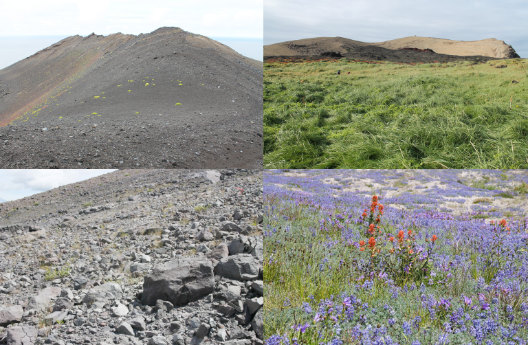
Vegetation on Surtsey (top, credit: Borgþór Magnússon) and Mount St Helens (bottom, credit: Roger del Moral). Images on the left are areas where the rate of succession is slow, those on the right detail areas with a faster succession rate.
In a world where environments are rapidly changing and species are having to move into new territories to adapt, these findings can help shed light on how plants could keep pace with the change as they shift from one site to the next.
By Sara Mynott, EGU Communications Officer
Reference:
del Moral, R. and Magnússon, B.: Surtsey and Mount St. Helens: a comparison of early succession rates, Biogeosciences, 11, 2099-2111, doi:10.5194/bg-11-2099-2014, 2014.

Lyle
Actually you can see the ultimate vegetative cover by looking at the vegetation at St. Helens before the eruption. Eventually it will again be tall conifers as it was back then. Actually the same thing shows for example on the Land Between the Lakes in KY where farms were moved out 60 years ago, and the land that is not mowed has gone to forests. Climax vegetation is a well known concept. You are reporting the first stages, but in a few hundred years assuming no eruption St. Helens will be at the climax stage.
Pingback: Geosciences Column: From the desolate to the diverse, a story of volcanic succession | GeoLog | Claudia Author Scientist