Thinking of the Arctic conjures up images of vast expanses of white icy landscapes punctuated by towering icebergs and a few dark rocky masses; certainly not a green landscape with a series of water pools amongst rolling hills. The image below is perhaps more reminiscent of the temperate Scottish or Welsh countryside; but don’t be fooled, out Imaggeo on Monday’s image was captured by Reinhard Pienitz (Laval University, Canada) in western Bylot Island, part of the Canadian Arctic Archipelago.
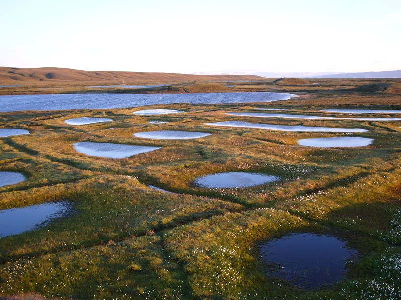
Polygon ponds at sunset. (Credit: Reinhard Pienitz, via imaggeo.egu.eu)
The uniqueness of Bylot Island is due to the convergence of a number of ecosystems. It lies to the north of Baffin Island and is dominated by high mountain peaks and glaciers. The southern plain of the island is at relatively low-elevations and covered by tundra vegetation. Wetlands are common in the low lying terrain where grasses, brown moss and sedges carpet the landscape. Think of them as ‘polar oasis’ which support hundreds of plant species and tens of animal and bird species. In contrast, the slopes of the hills are much drier and support shrubs, grasses and forbs.
The ground in the low-lying areas is perpetually frozen which means the drainage of water from the melted snow is hampered; it is the presence of this permafrost which allows the formation of the widespread wetlands. Year on year, organic matter accumulates, rising upwards, as the permanently wet and cold conditions mean it is very difficult for organic material to break down. As time passes, cyclic layers of peat and permafrost build up. The importance of the wetland ecosystem in the Arctic cannot be underestimated. The peat-rich soils constitute a net sink for carbon during the Holocene and are thought to store 97% of the tundra carbon reserve (Ellis et al., 2008).
Freezing over the winter months and thawing over the (slightly) warmer spring months drives the formation of the polygonal pattern seen across the wetlands of Bylot Island (and many other Arctic regions). As the ground freezes it contracts resulting in the formation of vertical cracks which penetrate the layers of peat and permafrost. The moist soils and meltwaters mean that there is plenty of water available to infiltrate the cracks, especially during spring. As the cold winter months approach the water freezes and the cracks expand, forming what are known as ice wedges, commonly connected at the surface, which give rise to the well-ordered polygonal pattern.
References
Ellis, C.J., et al. (2008), Paleoecological Evidence for Transitions between Contrasting Landforms in a Polygon-Patterned High Arctic Wetland, Arctic. Antarctic, und Alpine Research., 40, 4,624-637
Imaggeo is the EGU’s open access geosciences image repository. Photos uploaded to Imaggeo can be used by scientists, the press and the public provided the original author is credited. Photographers also retain full rights of use, as Imaggeo images are licensed and distributed by the EGU under a Creative Commons licence. You can submit your photos here.
Pingback: Cryospheric Sciences | Image of the Week — Biscuits in the Permafrost