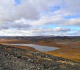
The Koukdjuak Plains (south-west Baffin Island, Canada) form a vast postglacial marine plain that borders the Foxe Basin, an area that has been progressively uplifted due to glacio-isostatic rebound following the end of the last glaciation about 6600 years ago. The weight of glaciers on the Earth’s crust causes the ground to be depressed, which, once the glacier melts, bounces back (at a geological pace) as the weight is lifted and the crust reaches a new equilibrium. The rate of rebound in this area can reach 1 cm per year, which is pretty fast for isostatic rebound!

The Foxe Basin and Koukdjuak Plains. Credit: NASA Visible Earth/Jacques Descloitres, MODIS Land Rapid Response Team
Rapid warming of the Arctic and extensive permafrost melt is causing many Arctic lake basins to be breached and drained. This is responsible for the widespread drying of lowland Arctic landscapes. Permafrost in this part of Canada has a high ground ice content, making the region particularly sensitive to a warming climate. As this melts, channels in the permafrost open, and can cause lakes to drain in less than a day!

“The drying Arctic” by Reinhard Pienitz, distributed by the EGU under a Creative Commons Licence.
In the Koukdjuak Plains, the carbonaceous bedrock of the Paleozoic Hudson Platform, one of the largest rock units in western Canada, is overlain by marine clays and glacial tills. These are topped with fine-grained lacustrine deposits, cracked following the drainage of the lake.
Reinhard Pienitz is reconstructing the paleoclimatic history of the Foxe Basin and took this photo while completing paleolimnological fieldwork (lake sediment coring). He explains that “extensive dry-ups of northern lakes like these can be observed in lowland areas across the Canadian Arctic, and [they] profoundly modify the hydrology and wildlife habitats of these northern landscapes”.
Reference:
Marsh, P., Russel, M. ,Pohl, S., Haywood, H. and Onclin, C. Changes in thaw lake drainage in the Western Canadian Arctic from 1950 to 2000, Hydrological Processes (23)1, 145-158 (2009).
Imaggeo is the EGU’s online open access geosciences image repository. All geoscientists (and others) can submit their images to this repository and since it is open access, these photos can be used by scientists for their presentations or publications as well as by the press and public for educational purposes and otherwise. If you submit your images to Imaggeo, you retain full rights of use, since they are licensed and distributed by the EGU under a Creative Commons licence.