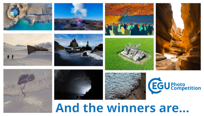
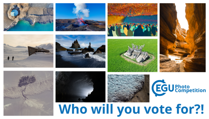
Archive | Photo Competition RSS feed for this section

Winners of the Imaggeo photo competition announced!

12 Apr

Congratulations to Philipp Stadler, Yiming Wang and Eva van Gorsel, winners of this year’s Imaggeo photo competition!

Winning image: Frost by Philipp Stadler

Second place: Icebear Rising by Yiming Wang

Third place: Regrowth after fires by Eva van Gorsel.

Imageo photos are distributed by EGU under a Creative Commons licence and are available in Imaggeo, the EGU’s online open access geosciences image repository. All geoscientists (and others) can submit their images to this repository and since it is open access, these photos can be used by scientists for their presentations or publications as well as by the press. 


Photo finalists! Do you have a favourite?

8 Apr

The selection committee received close to 200 photos for this year’s EGU Photo Competition, covering fields across the geosciences. The stunning finalist photos are below and they are being exhibited in Hall X (basement, Blue Level) of the Austria Center Vienna, where you will also find voting terminals.

Do you have a favourite? Vote for it! The results will be announced on Friday 12 April during the lunch break.

Gypsum Dunes by Robert Wills

Mendenhall Glacier by Daniele Penna

Mirror, mirror by Anna Nadolna

Greenland Ice Sheet by Andrew Sole

Smooth Ice by Kay Helfricht

Colourful hydrovolcanism by Stephanie Flude

Regrowth after fires by Eva van Gorsel

Icebear Rising by Yiming Wang

Frost by Philipp Stadler

Climate change is in our hands by Stephanie Flude

Black Sand Vortex by Yiming Wang

 These images are distributed by EGU under a Creative Commons licence and are available in Imaggeo, the EGU’s online open access geosciences image repository. All geoscientists (and others) can submit their images to this repository and since it is open access, these photos can be used by scientists for their presentations or publications as well as by the press. 


Photo competition at the EGU 2013 General Assembly

6 Feb

If you are pre-registered for the 2013 General Assembly (Vienna, 7—12 April), you can now submit photos and moving images to our annual competition! Winners receive a free registration to next year’s General Assembly.

The fourth annual EGU photo competition is now open! Up until 26 March, every pre-registered participant of the General Assembly can submit up to two photos on any broad theme related to the Earth, planetary, and space sciences. Short-listed photos will be exhibited at the conference and the winner will be voted for by General Assembly participants.

In addition, we will also be running a competition for the best moving image, for which we invite you to submit unedited films/footage no longer than 3 minutes in duration.

If you submit your images to the competition, they will also be included in the EGU’s open access photo database, Imaggeo. You retain full rights of use since photos submitted to the database are licensed and distributed by the EGU under a Creative Commons license. This means that Imaggeo content can be used by scientists for their presentations or publications, by the press for news articles, and others or education, blogs — you name it! — as long as they are attributed to the photographer.

You will need to register on Imaggeo so that the organisers can appropriately process your photos. For more information, please check the photo competition page on Imaggeo. Previous winning photographs can be seen on the 20102011 and 2012 winners’ pages.

In the meantime — get shooting!

Last year’s winning photo: Melt Stream by Ian Joughin, distributed by EGU under a Creative Commons licence.

Geotalk: Dr Olivier Galland

12 Dec

Geotalk, featuring short interviews with geoscientists about their research, continues this month with a Q&A with Dr Olivier Galland (University of Oslo), who tells us about his volcanology research and the importance of outreach in promoting the Earth sciences. If you’d like to suggest a scientist for an interview, please contact Bárbara Ferreira.

Olivier Galland at the foot of the Tromen Volcano, northern Patagonian Andes, Argentina, during a field expedition of Nov-Dec 2011. Photograph: Derya Gürer

First, could you introduce yourself and let us know a bit about your research topic(s)?

Becoming a volcanologist was my childhood dream, and my studies have always been oriented towards this goal. I first integrated the École Normale Supérieure in Lyon, then I completed my MSc and PhD degrees at the University of Rennes 1. I continued with a postdoc at the Norwegian Centre of Excellence for Physics of Geological Processes, University of Oslo, where I have become Senior Researcher.

My main research topics focus on the mechanics of fluid-rock systems and their implications on volcanic processes. In other words, what is the mechanical behavior of a system where a fluid of given properties flows into a deforming solid matrix? Such a system cannot be understood only from the point of view of the fluid or of the solid, but by the dynamic mechanical interplay between them. This fundamental mechanical loop controls numerous geological processes such as, among others, magma transport and emplacement in the Earth’s crust, hydraulic fracturing, and explosive volcanism. I have mostly addressed these processes through integration of field observations in volcanic systems and quantitative laboratory experiments.

Last year, you received an EGU Arne Richter Award for Outstanding Young Scientists for your “remarkable contribution to the understanding of volcanic and magma emplacement processes”. Could you summarize the research you have done in this area?

Magma transport plays a key role in the Earth’s dynamics, as it accounts for the main mass and heat transport through the crust. Although magmatism has been studied for more than a century, major questions have remained unsolved. For instance, geologists have assumed that volcanism can occur only in extensional tectonic settings, the extension providing space for magma pathways. This generally accepted assumption is contradictory with the occurrence of intense volcanic activity in the Andean Cordillera, where tectonic shortening has been coeval with volcanism. Part of my research work has demonstrated that volcanism can take place in compressional tectonic settings by focusing on a spectacular case study: the Tromen volcano, in the northern Patagonian Andes. Through several field campaigns at Tromen, we collected structural and geochronological evidence, which showed that the volcano built up during the regional tectonic shortening. To explain how magma can rise in such setting, I also designed a novel experimental apparatus that can simulate coeval tectonic deformation and the injection of low viscosity magma. The experimental results show that magma can migrate along thrust faults, strongly modifying our understanding of magma plumbing systems in active margins and volcanic arcs.

In 2008 you embarked on an exciting scientific expedition called the Andean Geotrail: “cycling 10,000 kilometers to discover the Earth and its resources”. Could you tell us about this adventure, including its aims and what you learnt from it?

The Andean Geotrail was a personal outreach project organized together with my partner, Caroline Sassier, also a geologist at the University of Oslo. The project was based on a 9-month cycling adventure in a spectacular geological environment: the Andean Cordillera. The aim was to use the adventure as a pedagogical tool to catch the attention of the young public and to trigger their curiosity through our own observations. This made Earth sciences less theoretical and more dynamic, and our hope was to create scientific vocations by sharing our scientific knowledge through a unique personal experience. Seventeen schools in France and Norway were associated, involving almost 600 pupils from 6 to 18 years of age.

During the expedition, we cycled from Ushuaia, southernmost Argentina, to Cuzco, Peru, and after the theft of our bikes, we walked to Nazca for a last 400 km long crossing of the Andes. We selected and visited more than 30 geological localities along the route to illustrate various implications of Earth sciences in our society (natural resources, natural hazards, geological landscapes). During the visits, we made our own observations and interviewed local geologists or workers. Since our return, we have presented the expedition in the involved schools and during public conferences, and produced an exhibition of our photographs.

By visiting the selected localities we obviously learnt a lot about the applications of Earth sciences in modern society. But overall, we gained an incredible human experience through the numerous encounters with the Andean populations.

You are also a keen photographer, and you were even one of the finalists of the 2012 EGU Photo Competition. How can Earth science photography contribute to promote the importance of geoscientific research among the wider public?

The most difficult challenge to attract the young generations is to overcome their initial reluctance to Earth sciences by catching their attention and triggering their curiosity about the Earth system. Our experience with the pupils during the Andean Geotrail clearly showed that it is a very challenging task without relevant support. During our conferences in the schools, the only way we managed to create a successful link with the pupils was to show them fantastic photographs of spectacular, unusual, strange and/or extreme geological patterns. Once this link has been established with the pupils, very interesting discussions started and it became possible to share our scientific knowledge with them.

Photography also has the potential to associate two communities that often barely interact: scientists and artists. In addition to be a fascinating scientific subject, the Earth and geological patterns are also unlimited sources of inspiration for artists and lovers of natural beauty. Photography of geological patterns is thus a precious way to promote geoscientific research and its associated challenges via artistic contemplation of the esthetic nature of the Earth.

Last but not least, what are your future research plans?

In the near future, I aim to expand my current work. I am leading a field-based project in the northern Patagonian Andes to unravel the structure of exhumed sub-volcanic systems emplaced in relation to thrust faults and folds, to better constrain the processes of magma transport in compressional tectonic settings. This is a good complement of the former project on Tromen volcano.

In addition, I aim to establish a quantitative bridge between volcano geophysics and laboratory models of volcanic processes. I am adapting my experimental apparatus to study the subtle ground deformation induced by the emplacement of magmatic dykes. Combined with new theoretical models, the provisional experimental results are expected to considerably help geophysicists to interpret ground deformation data monitored in active volcanoes with GPS and interferometry Radar (InSAR). In particular, this technique has the potential to provide a new tool to predict the location of forthcoming volcanic eruptions.

The Andean Geotrail project. Caroline Sassier lost in the immensity of the Bolivian Altiplano (4000 MOSL). Photograph: Olivier Galland


Imaggeo on Mondays: Melt Stream

28 May

Melt Stream, Greenland by Ian Joughin, distributed by the EGU under a Creative Commons license.

Supraglacial lakes are created when water forms in depressions on top of a glacier, remaining there until it dissipates by seeping through crevasses, or cracks in the ice sheet. Despite their sometimes impressive size, supraglacial lakes may drain in a matter of hours under the right conditions, when the pressure they exert on the ice causes it to crack creating a sometimes spectacular lake draining event.

Draining of supraglacial lakes may have important environmental consequences and may even, as warming temperatures further increase meltwater volumes, affect rates of sea-level rise by accelerating the rate by which ice sheets slide into the ocean.

Dr Ian Joughin, from the University of Washington Polar Science Center, took this breathtaking photo under freezing conditions, earning him the 1st Prize at the 2012 General Assembly photo competition. He explains, “This image was taken as part of a project investigating the rapid drainage of supraglacial lakes in Greenland. Each year, these lakes, which often are a few kilometers across and 10 or meters deep, fill with melt water. If the water can find an open crack, it fills the crack and the greater density of water relative to ice allows it to hydro-fracture through the full thickness (~1 km) of the ice sheet, causing the entire lake to drain rapidly (< 2hours). This picture shows a large melt stream that we encountered as we were out exploring the lake basin, and it is only one of many streams feeding the lake.”

Imaggeo is the online open access geosciences image repository of the European Geosciences Union. Every geoscientist who is an amateur photographer (but also other people) can submit their images to this repository. Being open access, it can be used by scientists for their presentations or publications as well as by the press. If you submit your images to imaggeo, you retain full rights of use, since they are licenced and distributed by EGU under a Creative Commons licence.

Imaggeo on Mondays: Icy Landscape

21 May

Icy Landscape by Lucien von Gunten, distributed by the EGU under a Creative Commons license.

Ice is a hazardous beauty, ephemeral in nature and, under the right conditions, capable of dominating landscapes. Earlier this year, while North America enjoyed an unusually mild winter, central and eastern Europe experienced brutal cold spells. The continent witnessed widespread freezing as cold air swept south from Siberia, claiming hundreds of lives, knocking out power supplies, and disrupting transport services. In Poland and the Ukraine, temperatures dropped as low as -33C and in Italy over 80,000 citizens were left without electricity after power lines were felled by trees.

This year’s icy spell brought Switzerland its coldest weather since 1987, the year it experienced its lowest ever recorded temperature. Lucien von Gunten, Science Officer at PAGES (Past Global Changes), explains the exceptional circumstances behind this captivating shot, taken earlier this year. “In Versoix, near the Lake of Geneva, the combination of low temperatures and strong easterly winds led to an unusual natural spectacle as the lake shores were partly covered with ice. Images of cars and boats under a thick ice shell were shown in the international press. Next to these popular eye-catchers one could also admire smaller scale ice structure, such as those depicted on this photograph, which covers an area of 30×30 cm.” This photo won 3rd Prize at the 2012 General Assembly photo competition.

Exceptional weather events, such as extreme temperatures, drought, or tropical storms and hurricanes, have increased in frequency over the past 50 years, partly as a result of human-induced climate change.

More pictures of Switzerland during this year’s freeze can be seen here.

Imaggeo is the online open access geosciences image repository of the European Geosciences Union. Every geoscientist who is an amateur photographer (but also other people) can submit their images to this repository. Being open access, it can be used by scientists for their presentations or publications as well as by the press. If you submit your images to imaggeo, you retain full rights of use, since they are licenced and distributed by EGU under a Creative Commons licence.

EGU2012 photo competition results

30 Apr

The three 2012 General Assembly photo competition winners are:

1st Prize (214 votes): Melt Stream, Greenland by Ian Joughin, distributed by EGU under a Creative Commons licence.

2nd Prize (142 votes): Burst by Melissa Bukovsky, distributed by EGU under a Creative Commons licence.

3rd Prize (135 votes): Icy Landscape by Lucien von Gunten, distributed by EGU under a Creative Commons licence.

Photo Competition at the General Assembly: the finalists!

23 Apr

The selection committee received close to 300 photos for this year’s EGU Photo Competition, in most areas covered by Union’s activities. The stunning finalist photos are below. Do you have a favourite? Vote for it! The photos are exhibited in Hall X (basement, Blue Level) of the Austria Center Vienna, where you will also find voting terminals. The results will be announced on Friday 27 April during the lunch break.

Water or new iridescent fluid? by Alessandro Arato, distributed by EGU under a Creative Commons licence.

Burst, by Melissa Bukovsky, distributed by EGU under a Creative Commons licence.

Nacreous clouds in Husavik, by Sigurjon Jonsson, distributed by EGU under a Creative Commons licence.

Icy landscape by Lucien von Gunten, distributed by EGU under a Creative Commons licence.

Russell Fjord (detail) by Jean-Daniel Champagnac, distributed by EGU under a Creative Commons licence.

The beauty of ice by Romain Schläppy, distributed by EGU under a Creative Commons licence.

Nevada landscape near Las Vegas by Norbert Krupp, distributed by EGU under a Creative Commons licence.

Melt stream, Greenland by Ian Joughin, distributed by EGU under a Creative Commons licence.

Flat in the mountains by Olivier Galland, distributed by EGU under a Creative Commons licence.


Photo competition at the EGU 2012 General Assembly

22 Feb

If you are pre-registered for the 2012 General Assembly (Vienna, April 22-27), we invite you to submit photos to our annual photo competition. Winners receive a free registration to next year’s General Assembly!

The third edition of the EGU photo competition is now open. Until 10 March, every pre-registered participant of the General Assembly can submit up to two photos on any broad theme related to the earth, planetary, and space sciences. Short-listed photos will be exhibited at the conference, with the winner voted by General Assembly participants.

If you submit your images to the photo competition, you agree to also submit them to the EGU photo database, Imaggeo. (You will also have to register on the website so that the organisers can  appropriately process your photos.) Being open access, it can be used by scientists for their presentations or publications, as well as by the press. If you submit your images to the database, you retain full rights of use, since they are licensed and distributed by EGU under a Creative Commons license. If a short-listed entry, you also agree for the photo to be exhibited at the General Assembly.

For more information, please check the photo competition page on Imaggeo. Previous winning photographs can be seen on the 2010 and 2011 winners’ pages.

Last year’s winning photo: Geysir by James Levine, distributed by EGU under a Creative Commons licence.

Imaggeo on Mondays: Water Angel

23 May

Water Angel

A “water angel” seems to appear in the upper part of the Trift Glacier Lake in the Swiss Alps. This image was a finalist in the EGU GA 2011 Photo Competition.

Image by Romain Schläppy, distributed by EGU under a Creative Commons licence.

Imaggeo is the online open access geosciences image repository of the European Geosciences Union. Every geoscientist who is an amateur photographer (but also other people) can submit their images to this repository. Being open access, it can be used by scientists for their presentations or publications as well as by the press. If you submit your images to imaggeo, you retain full rights of use, since they are licenced and distributed by EGU under a Creative Commons licence.

Follow

Get every new post on this blog delivered to your Inbox.

Join other followers: