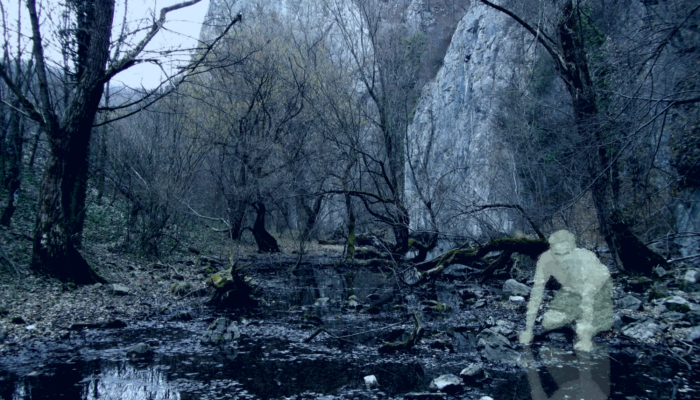
Archive | Stratigraphy, Sedimentology and Palaeontology RSS feed for this section

Imaggeo on Mondays: Stars in the sand

13 May

This week’s Imaggeo on Mondays is brought to you by the photographer herself, Jana Eichel, who tells us about her expedition to the Mingsha Mountains and the stunning aeolian landforms that characterise the landscape.

“Star dune in the Gobi desert, Dunhuang, China” by Jana Eichel, distributed by the the EGU under a Creative Commons licence.

This photo was taken during a journey through Asia in spring 2012, which took me across Bangladesh, India and Nepal through to Western China and into the Gobi Desert. This journey allowed me to appreciate the enormous variety of landscapes in Asia as well as  the different cultures. To experience ‘the desert’, which has fascinated me for quite a while, I joined  four others on an (ever so slightly touristy) overnight camel trek to the borders of the Mingsha Mountains, where this photo was taken. This megadune field is located south of Dunhuang (Gansu province, China) in the Gobi Desert. The dunes, which are aeolian depositional landforms, are between 60 and 170 m heigh and are formed mostly by westerly and southerly winds. In the neighborhood of this dunefield, the World Cultural Heritage of the Mogao Caves is located, which house a large collection of Buddhist art. There is a fear that they will be overrun by the Mingsha Mountains (megadunes) in the future, which are slowly advancing in this direction.

The Gobi Desert (source).

The image was taken from near the top of one of the large pyramid dunes at the northeastern border of the dunefield. From here you can see the foothills of the Mingsha Mountains with various dune types, which are determined by a multitude of influencing factors, including wind direction variability and sand supply. Our camp in the lower left of the picture puts these huge landforms into perspective.

Most prominently in the foreground next to the camp is a star-shaped dune. These dunes are generally formed by multidirectional winds when there is a large sand supply. These conditionscreate a set of slip faces that project out in  multiple directions, such that the dune represents a star – hence the name! Transverse dunes and barchanoid ridges can be seen in the background, where they phase out towards the plains, likely dues to a decreasing sand supply. Dunefields such as this, with a variety of dune types highlight the complexity of geomorphic systems, Aeolian systems, such as the one here are thought to be strongly driven by self-organisation. This means the complex non-linear dynamics of the system do not result in chaos but instead in order: the smallest elements in the system, such as the sand grains, assemble into larger scale objects, such as the dune patterns shown (Dikau, 2006). This emergent behaviour cannot be predicted even if all processes fundamental for the evolution of these dunes are known.

To account for the impressive landscape with its large-scale geomorphic forms, I used a high aperture to give the picture a greater depth. This was amplified by the sunset light, which  created long shadows behind the dunes and gave a better impression of the contours of the dunes, which are partly obscured during the day.

By Jana Eichel, University of Bonn  

References:

Dikau, R. (2006): Complex systems in geomorphology. Mitteilungen der Österreichischen Geographischen Gesellschaft 148, 125-150.

Jianjun, Q., Ning, H., Guangrong, D. and Weimin, Z. (2001): The role and significance of the Gobi Desert pavement in controlling sand movement on the cliff top near the Dunhuang Magao Grottoes. Journal of Arid Environments 48, 3, 357-371.

Kocurek, G. and R.C. Ewing (2005): Aeolian dune field self-organization – implications for the formation of simple versus complex dune-field patterns. Geomorphology 72, 94-105.

Imaggeo is the EGU’s online open access geosciences image repository. All geoscientists (and others) can submit their images to this repository and since it is open access, these photos can be used by scientists for their presentations or publications as well as by the press and public for educational purposes and otherwise. If you submit your images to Imaggeo, you retain full rights of use, since they are licensed and distributed by EGU under a Creative Commons licence.

Imaggeo on Mondays: The chalk cliffs of Étretat

29 Apr

Étretat is a coastal region in northern France, well known for its stunning geological landscape. Particularly the headland you see here.

“The chalk cliffs of Étretat” by Chiara Arrighi, distributed by the EGU under a Creative Commons licence.

Headland erosion is perhaps one of the best known processes in coastal erosion, where a crack in the headland is opened and enlarged by hydraulic abrasion. Continued wave action causes the widened crack or cave to break through the headland and form an arch. As erosion continues, the arch collapses, leaving behind a stack (or needle) that erodes down to its base to form a much smaller stump. There are some great examples of other coastal processes describes in The British Geographer.

How headlands form and coastal arches erode. Source: Sbsgeog’s Weblog.

But that’s not all there is to Étretat, the chalky cliffs are composed of several layers, clearly distinguishable in Arrighi’s photo. These chalk layers are of varying hardness and can be clustered into three main strata: the lowest is a light, fine, stratified chalk aggregate, rich in foraminifera; the middle stratum is a compact chalk layer with beds that are tens of metres thick, and the uppermost stratum is composed of chalk nodules that, like the lowest stratum, is rich in foraminifera.

These strata provide insight into how the chalk of the region was laid down: the fine strata would have been a calcareous ooze, deposited by gentle currents and the nodular material would have formed as small “bullets”, before accumulating more calcareous material as they are transported and redeposited elsewhere. The sediments that now make up the Étretat chalk sequences were subject to several episodes of deformation and slumping before cementing to form the layered cliffs you see above.

References:

Dercourt, J. and Paquet J. (1985). Sedimentary Facies. Geology Principles and Methods, pp. 195-206.

Bromley, R.G. and Ekdale A.A. (2006) Mass transport in European Cretaceous chalk; fabric criteria for its recognition. Vol. 34, pp.1079-1092.

Imaggeo is the EGU’s online open access geosciences image repository. All geoscientists (and others) can submit their images to this repository and since it is open access, these photos can be used by scientists for their presentations or publications as well as by the press and public for educational purposes and otherwise. If you submit your images to Imaggeo, you retain full rights of use, since they are licensed and distributed by EGU under a Creative Commons licence.

Geosciences column: Perfecting palaeogeographic reconstructions

26 Apr

We model the changes in the geographic location of continents via paleogeographic reconstructions. However, the current methodology for generating these reconstructions is not without problems! Publication of palaeogeographic reconstructions is scarce, probably resulting from the difficulties associated with generating them. Conventional reconstructions are presented as static maps which have poor spatial and temporal resolution. In addition, they are often difficult to replicate as the ‘input data’ used to produced the reconstructions is usually not included in publication. Reconstructions quickly become outdated as the models they are superimposed onto are improved and become more refined.

In Biogeosciences, Wright et al. (2013) present a new method which hopes to overcome some of the issues associated with conventional palaeogrographic reconstructions. Combing the open-source plate motion reconstruction tool, GPlates, with paleobiological data the aim is to uncover spatial and temporal correlations and test the reliability of existing reconstructions. GPlates allows for easy modification and updating of reconstructions and is easily linked to already established models. The new method is tested against the already existing publicly accessible Palaegeographic Atlas of Australia (Totterdell, 2002). It contains 70 palaeogeographic time slices for the Phanerozoic derived from palaeoenvironmental reconstructions, tectonic histories and other geological evidence. In addition, the model is supplemented with fossil indicators from the open-access Palaeobiology database.

Fossil collections (a), palaeogeographical reconstructions taken from the Palaeogeographic Atlas for Australia (b), are reconstructed in GPlates (c) using the Phanerozoic plate motion model (d) and data associations, as per the Emsian example (e) to test and refine the palaeogeographic and plate motion models (click for larger). Source: Wright et al., 2013.

In order to generate their own plate reconstruction in 1Myr intervals in GPlates, for the Australian Phanerozoic, the authors based their relative plate motions on work by Dr. Jan Golonka. The plate motions are derived from palaeomagentic data and Apparent Polar Wander Paths (APW) and are further supported by geological observations, such as location of orogenies and sedimentary basins. A number of taxonomical data were acquired from the Palaeobiology database and assigned GPlates mark-up language so that the data could be included in the new reconstructions. The time scales between the Palaoegeographic Atlas of Australia and the Paleobiology database differed, so they were standardised. The spatial and temporal associations between the palaeogeography and fossil collections were tested for inconsistencies. Where these arose; the fossil collections were taken as the true representation of the palaeoenvironment. For example, if the fossils indicated a truly marine environment, whilst the palaeogeography suggested a terrestrial setting, this was flagged as an inconsistency in the model that needed refining.

The new model has allowed the authors to gain a detailed understanding of the plate tectonic movements of Australia during the Phanerozoic. The article goes into much greater detail than I intend to do so here, I refer you to the article itself if you want more information! During the Cambrian, the new model suggests that Australia spanned equatorial latitudes and formed part of Gondwana. By the Palaeozoic, the Northern margin of Gondwana (North and South China, Tibet and Indochina, amongst others) had detached and this marked the onset of opening and closing of a number of palaeo-Asiatic and Tethys basis. The remaining Pangaea further breaks-up during the Cretaceous, with India and Australia moving northwards, away from Antarctica.

Temporal coverage of eastern Australia basins (EA) and the Eromanga Basin (EB). The data gaps may be related to sampling gaps, orogenic episodes and the influence of glaciations during the late Palaeozoic. Source: Wright et al., 2013.

Palaeogeographic and biofacies data can be embedded into the plate tectonic models in order to uncover inconsistencies and refine the reconstructions. The clear benefits of including palaeobiological data are highlighted during the Emsian time period (402Ma). The paleogeographic reconstruction from the Atlas for Australia proposed a land environment for deposition at this time, whilst the fossil and lithological evidence, suggest a marine environment. Temporal ranges of fossils in relation to the deposition of their associated Formations were problematic and no formations which displayed age disagreements were included in the new model.

Whilst the inclusion of paleobiological data is clearly beneficial to the construction of the models, geographical and temporal gaps in the fossil record, compromise the accuracy of the plate reconstructions. In some cases the gaps in the fossil record are simply due to a sampling bias, but in others it is not clear if the issue is fossil preservation or the environment at the time of deposition.  As a result, other data are required as a proxy for biological data. Improvements to the models could be made by including other paleoenvironment indicators such as data from well logs could be included in future models. To further improve the methodology, it is important to remember that sediments and fossils deposition is often confined to basins. In future, it would be valuable to included elevation data or proxies for these into the models. GPlates will also soon allow the incorporation of chronostratigraphic data (Sikora et al., 2006) as well as paleobiological data.

By Laura Roberts Artal, PhD Student, University of Liverpool

References:

Golonka, J.: Late Triassic and Early Jurassic palaeogeography of the world, Palaeogeogr. Palaeocl., 244, 297–307, 2007.

Totterdell, J. M.: Palaeogeographic Atlas of Australia, Geoscience, Australia, 2002.

Sikora, P. J., Ogg, J. G., Gary, A., Cervato, C., Gradstein, F., Huber,B. T., Marshall, C., Stein, J. A., and Wardlaw, B.: An integrated chronostratigraphic data system for the twenty-first century, Geoinformatics: data to knowledge, 397, 53–59, 2006.

Wright, N., Zahirovic, S., Müller, R. D., and Seton, M.: Towards community-driven paleogeographic reconstructions: integrating open-access paleogeographic and paleobiology data with plate tectonics, Biogeosciences, 10, 1529-1541,  2013.

Imaggeo on Mondays: Wonderings and weathering

18 Feb

After studying ‘Applied Environmental Sciences’ I decided to go with a friend for six months to New Zealand for the southern hemisphere winter. Leaving as soon as my diploma thesis (on epiphytic lichens) was written, we set off into the distance to work and travel. We chose New Zealand as our dream destination because these two islands have so many different landscapes to offer – and this is how I was able to capture this picture:

“Honeycomb Weathering” by Stefanie Boltersdorf (University of Trier, Germany), taken on the Kaikoura Peninsula, New Zealand. This photo is distributed by the European Geosciences Union under a Creative Commons License.

The photo shows honeycomb weathering on the Kaikoura Peninsula, with extends from the East coast of the South Island. Composed of mudstone and limestone, the terraces were once wave-cut platforms and have since been uplifted and deformed (during the Quaternary). The peninsula extends into the sea and encounters the relatively shallow Chatham Rise, an area of ocean floor to the east of New Zealand that was largely dry during the Cretaceous period, but now lies nearly 1000 metres underwater. This area is also one of the region’s most productive fishing grounds, a consequence of the nutrient-rich water that upwells along the coast. At low tide, the ocean gives way to a rocky floor, which is easily navigable by foot for quite some distance – and from there you can have a better view of the local seals and seabirds. At this spot, a branch of the Southern Alps, the so-called Seaward Kaikoura Range, comes close to the sea.

Very early in the morning, after sleeping next to the sea and having breakfast in our small van, ‘Berty’, the tide was very low and we took the opportunity to go for a walk. It was on this adventure we found this stunning structure, peppered with small molluscs that were sheltering in the eroded depressions. These depressions are a consequence of honeycomb weathering – a process initiated when salt meets porous rock. Sea spray delivers salt to the rocks, which, after the water has evaporated, is deposited in the pore spaces. Over time, the salt crystals push the minerals apart and weaken the rock. Small pockets collect seawater and erode into ever-larger depressions, eventually creating this marvellous honeycomb structure.

Although I have been dealing with epiphytic lichens during my diploma thesis, I remained true to them, even after my trip. After my return, and inspired by my trip to the highly lichen-rich New Zealand, I started my PhD thesis – investigating a method of quantitatively and qualitatively assessing nitrogen deposition in lichens, with the help of stable isotopes.

By Stefanie Boltersdorf, with Geo-facts from Sara Mynott

Imaggeo is the online open access geosciences image repository of the European Geosciences Union. Every geoscientist who is an amateur photographer (but also other people) can submit their images to this repository. Being open access, it can be used by scientists for their presentations or publications as well as by the press. If you submit your images to imaggeo, you retain full rights of use, since they are licenced and distributed by EGU under a Creative Commons licence.

Imaggeo on Mondays: Rainbow in stone

28 Jan

“Rainbow in stone” by Marina Manea, distributed by the European Geosciences Union under a Creative Commons licence.

Nothing better characterises the wild US West than endless landscapes of red hoodoos, spires of rock protruding from the bottom of an arid drainage basin or badland. Found mainly in desert and dry, hot areas, hoodoos are distinctive from similarly-shaped formations, such as spires or pinnacles, because their profiles vary in thickness throughout their length. Their distinctive colour bands are the product of erosional patterns differentially affecting layers of harder and softer minerals.

Nowhere in the world are hoodoos as abundant as in the northern section of Bryce Canyon National Park in Utah, USA. There, these formations, also known as goblins or in French as demoiselles coiffées (“ladies with hairdos”), dominate the landscape.

At Bryce Canyon, hoodoos are formed by two continuously operating weathering processes. The first, frost wedging, occurs as a result of Bryce’s over 200 annual freeze/thaw cycles. In the same way potholes are formed on a paved road, water breaks open the rock when it seeps into cracks, freezes, and expands. Secondly, the hoodoos are also sculpted by rainfall, both physically, because it removes debris, and chemically, because its slightly acidic pH dissolves the limestone.

Marina Manea, who works in the Computational Geodynamics department of the Universidad Nacional Autonoma de Mexico, took this early-morning picture from a helicopter whilst on holiday in Utah in August 2010. She explains, “Bryce Canyon has a unique geology, with deposits from the late Cretaceous and early Cenozoic eras. It is not a classical canyon but, rather, a collection of amphitheaters modelled by the erosional force of frost-wedging and the dissolving power of rainwater acting on the colorful limestone rock of the Claron Formation. In this way, the spires, or ‘hoodoos,’ are formed. The rocks forming the hoodoos are limestone (sedimentary rocks) exhibiting beautiful colours (red, orange, or white). The entire geology of the Bryce Canyon is related to the geology of the Grand Staircase region and Black Mountains volcanic complex. It rained just before this picture was taken, which explains the exceptionally vivid colours on display here.”

The area around Bryce Canyon was originally settled by Native Americans and later by Mormon pioneers. The national park was established in 1928 and today around 1.3 million (2011) people annually travel to witness its wild terrain and spectacular sunset colours.

Imaggeo is the online open access geosciences image repository of the European Geosciences Union. Every geoscientist who is an amateur photographer (but also other people) can submit their images to this repository. Being open access, it can be used by scientists for their presentations or publications as well as by the press. If you submit your images to imaggeo, you retain full rights of use, since they are licenced and distributed by EGU under a Creative Commons licence.

Imaggeo on Mondays: Ellesmere Island

24 Dec

“Ellesmere Island” by Jean-Daniel Champagnac, distributed by the European Geosciences Union under a Creative Commons licence.

Located within the Canadian Arctic Archipelago, Ellesmere Island is the world’s tenth largest island and features Canada’s most northerly point but little else apart from vast landscapes of pristine natural habitat. It is separated from Greenland only by the Nares Strait, a major pathway for sea ice flushing out of the High Arctic.

Belonging to the Canadian territory of Nunavut, Ellesmere’s permanent population is under 200, most of whom endure the hostile weather found at Grise Ford, where the annual temperature is a staggering -16.5°C.

It comes as no surprise, then, that this mosaic of colours was captured from high above Ellesmere’s unforgiving environment. Jean-Daniel Champagnac, of the Geological Institute of the Swiss Federal Institute of Technology, Zurich, explains, “This picture was taken through the window of an airplane cruising at around 10,000m en route between Frankfurt, Germany and Anchorage, Alaska. Here you can see the bare rock of Ellesmere Island, with presumably folded sedimentary rocks, and a frozen fjord being unglaciated. This picture, taken in June 2011, has been quite substantially modified from the raw initial picture.”

As with many untouched Arctic environments, it is thought Ellesmere may be rich in natural resources, specifically in thermal coal deposits used to produce heat and electricity. If confirmed, this finding could be pivotal for the future of Nunavut. Canada’s mostly-aboriginal territory (83.6% Inuit, according to the 2006 census) is currently experiencing an energy crisis.

About his picture, Champagnac concludes, “It is always worth having a camera along when you fly, especially on a clear day.” We couldn’t agree more and we encourage you to submit more of your aerial shots to Imaggeo.net.

Imaggeo is the online open access geosciences image repository of the European Geosciences Union. Every geoscientist who is an amateur photographer (but also other people) can submit their images to this repository. Being open access, it can be used by scientists for their presentations or publications as well as by the press. If you submit your images to imaggeo, you retain full rights of use, since they are licenced and distributed by EGU under a Creative Commons licence.

How interviews of famous geologists can help you learn more about geosciences

16 May

Today’s guest post comes from Daniel Minisini, a geologist with a passion for filming and philosophy who created a resource for the geosciences community called minigeology.com. In this post, he tells us a bit more about the website, and the inspiration behind the interviews he conducts and posts online.

Hi! I am Daniel, a sedimentologist and stratigrapher trained as a marine geologist by my maestro Fabio Trincardi in Bologna (Italy). I have studied and worked on modern submarine sediments, ancient turbidites, and black shales, by means of outcrops, cores, seismic data and well logs, around the Mediterranean and North America. Now I work at the Shell Research Laboratories and I live in Houston, capital of geologists. My free time is dedicated to a personal project called minigeology.com, a website where I video-interview protagonists and other characters within the Earth sciences.

It came naturally to me to start video recording the several smart geoscientific minds surrounding me and sharing their thoughts with all of you. Therefore, a couple of years ago, I decided to create a platform to do precisely that. The interviews spark from a variety of thoughts and questions I ask myself, about geology, its origins, its progress, and its relationship with other disciplines.

I still have much to understand about my own research. There are many topics in my research area that I take for granted because I read about them in books and scientific articles, but how did they originate and develop? How does my specific research topic fit in the wider context? And what should I answer when asked: “What is that useful for?”

[vodpod id=Video.16473498&w=432&h=243&fv=showSharing%3Dfalse%26amp%3BshowRelated%3Dtrue%26amp%3BfeedUrl%3Dhttp%253A%252F%252Fwww.minigeology.com%252Fvideo%252F523213.json%253Fembed%253D0%26amp%3Blogo_placement%3Dtr%26amp%3Btheme%3D%23ff0000%26amp%3BreloadRelatedVideos%3D1]

Please click here if the video doesn’t play.

Through minigeology.com, I try to find answers to these and other questions by indirectly investigating how geoscientists approach a problem, their work, and their life. The interviews are informal and the format yields a short spontaneous discussion. By asking the ‘right’ questions, the interviews aim to stimulate the viewer to ask his or her own questions in their own research.

All geoscientists are part of minigeology.com, which works as a square to meet personalities in the Earth sciences on one hand, and as a round table for everyone to take part in the discussion on the other. Have an idea for an interview? Then email me by clicking the name below or upload your own video to the website.

By Daniel Minisini

Make sure to check a recent interview Daniel conducted with the 2012 Jean Baptiste Lamarck EGU medalist, Emiliano Mutti!

Imaggeo on Mondays: A mineral under the microscope

9 Apr

Epidote by Gunnar Ries, distributed by EGU under a Creative Commons license

Epidote, an abundant rock-forming mineral found in metamorphic rocks, nearly always appears in green, although it may vary in shade and tone. Under a microscope of polarized light, however, it exhibits strong pleochroism, that is, it shows different colors when observed at different angles. The thin section (a laboratory preparation of a mineral or rock sample for use with a polarizing microscope) in the picture displays strong yellow colours, beautiful tones of pink and purple, and light and dark shades of blue.

This photography under a microscope was taken by mineralogist Gunnar Ries. He comments, “I took this picture in 1996 from a unakite sampled in the German state of Mecklenburg-Vorpommern, near the town of Rerik, during a field trip. The thin section was one of the first I ever made!”

Although Epidote can be found worldwide, including in Pakistan, China, and across Africa, it is particularly prevalent in the Austrian Alps, where it appears in the form of distinctly large, sharp, and lustrous crystals. Epitode is often seen on display at mineral conventions, with the finest pieces – featuring delicate and elongated crystals – being highly treasured by collectors.

Imaggeo is the online open access geosciences image repository of the European Geosciences Union. Every geoscientist who is an amateur photographer (but also other people) can submit their images to this repository. Being open access, it can be used by scientists for their presentations or publications as well as by the press. If you submit your images to imaggeo, you retain full rights of use, since they are licenced and distributed by EGU under a Creative Commons licence.

Imaggeo on Mondays: Praia das Rodas, Spain

19 Mar

Praia das Rodas by Jorge Mataix-Solera, distributed by EGU under a Creative Commons licence.

Often listed as one of the most beautiful beaches in the world, Praia das Rodas is located on the Isla do Faro, part of the three-island Cíes archipelago within the Atlantic Islands of Galicia National Park. The beach faces eastwards, towards Vigo and the Galician coast of northwestern Spain, its accumulation of sand forming a land-bridge between two islands during low tide. All three islands are the visible peaks of submerged granitic mountains.

Soil scientist Jorge Mataix-Solera visited Praia das Rodas in 2007. “The picture was taken when I arrived by boat to the island in the early morning, the day after I was on a PhD thesis evaluation committee at the University of Vigo. This beach is one of the most beautiful beaches in the world, composed of quartz sand from granitic material,” he explains.

Beaches form over thousands of years from the deposit of sediment and other materials that moves from land into the ocean and back again.

To view more from Jorge Mataix-Solera’s astounding collection of photos, please visit: http://www.jorgemataix.com.

Imaggeo is the online open access geosciences image repository of the European Geosciences Union. Every geoscientist who is an amateur photographer (but also other people) can submit their images to this repository. Being open access, it can be used by scientists for their presentations or publications as well as by the press. If you submit your images to imaggeo, you retain full rights of use, since they are licenced and distributed by EGU under a Creative Commons licence.

Our next door neighbours

7 Feb

The EGU Executive Office is housed in one of the buildings of the Department of Earth and Environmental Sciences of the Ludwig Maximilian University of Munich, Germany. The building also hosts the Palaeontological Museum Munich, the public part of the Bavarian State Collection for Palaeontology and Geology, which is dedicated to the history of life and the Earth, and displays fossils from all eras of the planet’s history.

Edvard Glücksman, the new EGU Science Communications Fellow, likes to access the building using the entry on Richard-Wagner-Straße, which gives direct access to the Museum. Yesterday, he decided to photograph what he sees every morning:

Dinosaurs at the Palaeontological Museum, Munich

Edvard took this picture using the Photosynth app on his iPhone, which allows you to stitch together various photos into a panorama. Check out the 3D interactive version on the app’s website!

Follow

Get every new post on this blog delivered to your Inbox.

Join other followers: